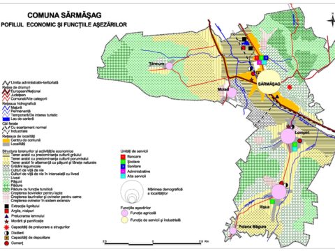
Creation of a spatial database of drone imagery and vector and 3D derivatives 
Elaboration period: 27.05.2021 – 01.06.2023
Beneficiary: Aiton Mayor’s Office (Cluj County)
Project Manager: Lecturer Gheorghe-Gavrilă Hognogi, PhD
Designed as an absolutely necessary service for any administrative-territorial unit, the creation and updating of a spatial database is also the object of this consulting contract, whose beneficiary is the Mayoralty of Aiton. During its one-year implementation period, the included activities will aim to update the administrative numbers in the commune of Aiton in order to conduct the 2021 General Census of Population and Housing, create orthophotomaps based on drone imagery, and other 2D and 3D derivatives usable in GIS software. The possibility of visualization in 3D format and the multiple scales of representation open the way, by updating and completing, to 5D LIS (Land Information System), which is a natural approach for a commune in the Cluj metropolitan area.